

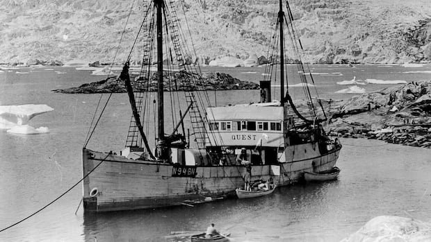

An upcoming expedition, funded by the Royal Canadian Geographical Society (RCGS), aims to thoroughly document the wreck of the Quest, which lies almost 400 meters beneath the Labrador Sea since its sinking in 1962. This initiative, supported by private donors and corporate sponsors, seeks to create an advanced digital replica of the vessel that carried renowned Antarctic explorer Sir Ernest Shackleton on his final journey. Utilizing cutting-edge Canadian underwater imaging technology from Voyis, based in Waterloo, researchers plan to construct a detailed three-dimensional model of the wreck. Subsequently, they will survey Terra Nova, the ship that transported British explorer Robert Falcon Scott to Antarctica.
CBC News will be the exclusive media presence on the research vessel Atlantis during the voyage to the shipwreck sites. The 21-day expedition, departing from the Woods Hole Oceanographic Institute in Massachusetts on July 2, marks a significant shift in underwater archaeology, focusing on digitally documenting delicate shipwrecks rather than physical retrieval.
The expedition’s chief scientist, David Mearns, views this undertaking as a unique opportunity to create comprehensive digital records of both Quest and Terra Nova. Shackleton, a prominent figure in Antarctic exploration, passed away aboard Quest in 1922 near South Georgia. The wooden vessel continued in service for several decades, serving in the Canadian navy during World War II before meeting its fate off Labrador in 1962.
Situated less than 500 meters off Labrador’s south coast, the Quest’s wreck lies in approximately 400 meters of water. Following this documentation, the expedition will move on to Terra Nova, resting in around 170 meters of water south of the Greenland mainland. The 2024 discovery of the Quest’s wreck has raised hopes that the RCGS expedition will provide insights into the condition of the wreck and its surrounding debris field.
Before delving into these inquiries, Mearns emphasizes the importance of visually confirming the ship’s identity through photographic evidence. Beyond identification, researchers are eager to explore the debris field surrounding the wreck, believing that scattered objects may offer valuable insights into the ship’s final moments.
To achieve their goals, the expedition will leverage lasers, stereo cameras, and sophisticated software to create a detailed digital model of the wreck and its surroundings. Voyis, a Waterloo-based company specializing in underwater imaging, will lead this effort, drawing on their experience in creating digital replicas of notable shipwrecks like the Titanic and Endurance.
Unlike conventional underwater surveys relying on divers, digital photogrammetry ensures safer and more precise data collection, enabling researchers to analyze findings long after the expedition concludes. Voyis, primarily serving industries like oil and gas and civil infrastructure, sees expeditions like Quest as opportunities to apply their technology to scientific exploration.
Despite the anticipation surrounding the expedition, success is not assured, given the challenging conditions of the Labrador Sea. Unpredictable currents and poor visibility at depths could pose significant hurdles. Strong currents at nearly 400 meters below the surface may impact the operation of the remotely operated vehicle, requiring meticulous navigation around the wreck to ensure a successful outcome.